
Unique, Beautiful, Sweetwater Mountains of Eastern California
By Del Albright (first written in 2004)
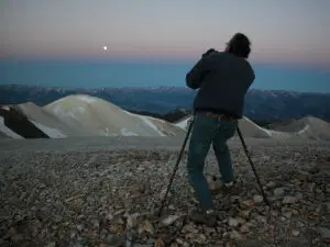
Sunrise seems like a slow process when you’re watching from 11,000 feet in elevation on a cold morning. The mountains were still beautiful, reflecting the last glimmer of moonlight. We could feel the bite of the predawn chill on our ears as my fellow wheelers and I waited patiently for the light to climb high enough for some picture taking.
We were miles from nowhere and anyone. We were one with nature. We had SUV’d our way to the top of the world, waiting for the magical moment of sunrise.
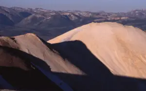
Photo Copyright 2002 by Del Albright
The Sweetwater Mountain Trail is a little-known SUV route outside the town of Bridgeport, in the Great Basin country near the border of California and Nevada. In fact, the trail doesn’t really have a name other than a USFS road number. Some folks call it the Wheeler Ridge Trail as you have to pass Wheeler Peak before getting to the top. Other folks call it the Mt. Patterson Trial (as it is the highest point of the trail). Most folks just call it the Sweetwaters Trail.
Sweetwater Mountains, in California and Nevada, a North-South range just east of the Sierra Nevada, in Lyon County, western Nevada; and Mono county, East California, rises to 11,654 feet at Mt. Patterson.

The Sweetwater Mountains are located between West Walker River and East Walker River at the north end of Mono county, at the boundary of the Sierra Nevada. Extending from the low surrounding valleys at approximately 6,000 feet to the high alpine area of Mt. Patterson at 11,654 feet, these mountains provide the visitor with an experience of transition from the Sierra Nevada on the west to the Great Basin on the east.
The western slope is well watered with streams and extensive forests of lodgepole and limber pine. The eastern slope is drier and feels more like the Great Basin ranges marching off to the horizon. The crest is distinctive because of the multi-colored, rocky peaks (many of them Rhyolite) rising well above timberline.
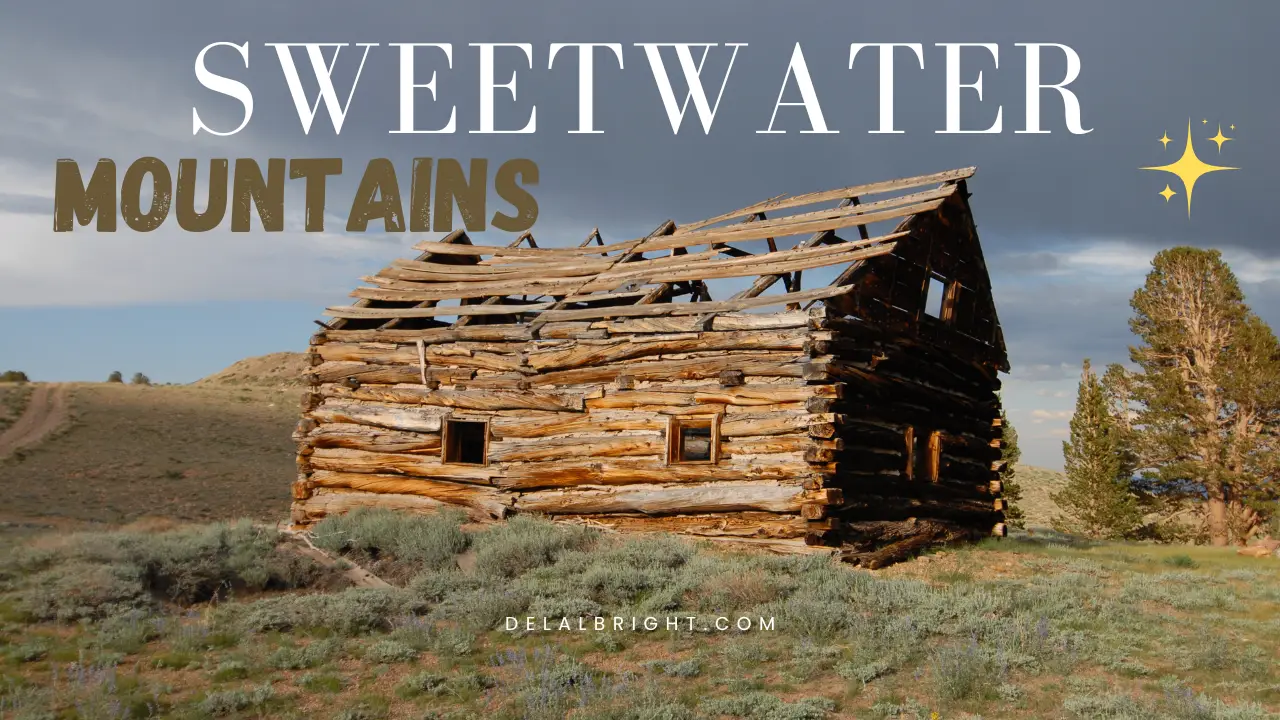
Historical signs of old mining sites can be discovered by an explorer in some of the areas. The old historic town of Belfort, California, still has buildings standing at 10,200 elevation along the trail.
The east entrance trail starts on Highway 338 about seventeen miles north of Bridgeport, California, at the Sweetwater Ranch, a private land and cattle operation. You drive through the ranch property (respectfully) to start the trail. You pass two or three ranch buildings before hitting an unlocked gate that you pass through (and close). Immediately you are in rocky desert terrain, bouncing along, seeing the Sweetwater Mountains off to your right. Your 4×4 or side by side will serve you well here.
From this elevation of 6000 feet, you wind your way up the mountain following USFS route 198 (some carsonite markers show you the way). In about three hours of driving, you will transition through sagebrush and pinion pine terrain, to Sierran forests, to alpine rocky barren slopes.
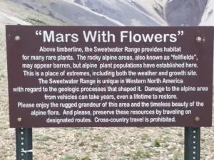
When you hit the top of the ridgeline, you’d swear you were on Mars. The colors and hues will amaze you, as will the lack of apparent vegetation. The rocks and minerals that cover the top of the Sweetwaters are truly unique and awe-inspiring. In fact, the alpine area on top is now labeled “Mars with Flowers.”
Along the way there are many “Kodak” moments, so be sure to take your camera. The views stretch for miles and you won’t see houses or roads. During the summer, you will find wildflowers galore, from Lupine to Mules Ears to Penstemon to Buckwheat.
I’ve seen literally acres of flowers in bloom, clustered together like shoppers at a new Wal-Mart opening. One reference book of mine says there are over 1,100 taxa in the Sweetwater Mountain range.
A good map is essential for this trip. There are a few side roads and plenty of firewood cutting offshoots that can confuse you. But, if you stick to the main route and follow your map to Mt. Patterson, you’ll be fine. You won’t need lockers for this trip. Back in the day, my 2002 Jeep Liberty (stock vehicle) made it just fine, but you do need to pay attention to the road in places as there are a few rocky stretches that will challenge your skill just enough to make it fun.
I also recommend carrying some survival gear for a trip like this. You can get up and down the mountain in one day, but if anything were to go wrong you’re a long way from help. Carry plenty of water, a warm blanket, some snacks, and your cell phone, and/or ham/GMRS radio. Wear good hiking shoes also. You may be inspired to take one of the hundreds of walking side trips. The area beckons to the explorer in all of us.

The Sweetwater Mountain Trail is a through trail if you care to take all day. From Hwy 338 on the east slope to Hwy 395 on the west slope, you can travel up and over the mountains. The scenery and view are different depending on your direction of travel, so you won’t be bored. It’s truly a wonderful SUV run and a mountain adventure that you won’t soon forget. I go back every year and enjoy it more each time. You can find more info on OnX Off-Road, or any one of a number of good mapping apps these days.